

Quick answer
The pico do fogo climb begins from Chã das Caldeiras at 1,600 meters elevation and ascends 1,229 meters over approximately 3-4 hours to the summit crater rim. The trail is open year-round with free park access, though a paid local guide is required and must be arranged separately. Early morning starts between 05:00 and 07:00 provide cooler temperatures and clearer visibility before afternoon clouds obscure the summit.
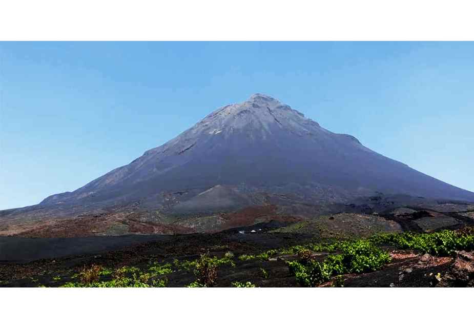
Fogo's summit crater last erupted in 2014, spilling lava flows that reshaped the caldera floor and destroyed several villages in Chã das Caldeiras. The volcano remains geothermically active, with steam vents visible near the crater rim and sulfur deposits coloring the rock yellow and orange. Climbers ascend through three distinct zones: cultivated vineyards and fig orchards in the lower caldera, a barren mid-section of volcanic scree, and the steep upper cone where loose ash gives way beneath boots with every step. The standard route follows a southwest-facing ridge from the caldera settlement, initially crossing hardened lava fields before attacking the cone's flank. No technical climbing skills are required, but the ascent demands cardiovascular fitness and mental resilience—the final 400 vertical meters traverse deep ash where progress feels measured in inches rather than meters. Trekking poles provide essential stability, and gaiters prevent boots from filling with volcanic grit. Wind intensifies near the summit, where exposed sections require careful footing along the crater rim. Local guides set the pace and identify the safest route variations, which shift seasonally as erosion rearranges the ash channels. Cape Verde regulations mandate guided ascents for liability and safety reasons, though enforcement remains informal. Most climbers arrange guides through Chã das Caldeiras guesthouses the evening before departure. The descent takes roughly half the ascent time but punishes knees and ankles as loose scree accelerates every step. Afternoon cloud cover typically rolls in by midday, reducing visibility and photographic opportunities, which explains the universal recommendation for dawn starts. The volcano's isolation in the Atlantic means weather changes rapidly. Clear morning skies can transition to summit fog within an hour, and winter months occasionally bring high-altitude rain. Water sources do not exist above the caldera floor, so climbers must carry sufficient hydration for the full round trip—typically two to three liters minimum. The summit crater measures roughly 500 meters in diameter, with a central cone that vents sulfurous gases. Standing at the rim, the view extends across the caldera to the Atlantic coast and neighboring islands on clear days, a reward that makes the ash-choked ascent worthwhile.
“The final 400 vertical meters traverse deep ash where progress feels measured in inches rather than meters.”
The Optimal Start Time for Your Pico Do Fogo Climb
The best arrival window for your climb is 05:00–07:00. An early start is essential to mitigate midday heat and ensure optimal visibility for the summit trek.
November to March
Low to moderateCooler temperatures, 15°C to 22°C
Dryer conditions favor longer hiking durations.
April to June
ModerateIncreasingly warm, 20°C to 26°C
Clear skies provide consistent views of the caldera.
July to October
HigherWarmest periods, 22°C to 28°C
Earlier starts are critical to avoid peak afternoon temperatures.
Verdict: The optimal approach is to plan your ascent between November and March, arriving at the base between 05:00–07:00.
Step-by-Step Guide to the Pico Do Fogo Climb
The Pico do Fogo climb follows a direct volcanic scoria path from Chã das Caldeiras to the 2,829-meter summit, typically requiring 3–4 hours ascent and 1–2 hours descent. The route is physically demanding but non-technical, with loose volcanic gravel underfoot throughout.
Arrange a Local Guide in Chã
All climbers must hire a certified local guide from Chã das Caldeiras village; arrange this upon arrival or the evening before your climb, as guides cannot be pre-booked from outside the caldera.
Start the Ascent Before Sunrise
Begin walking from the trailhead at the caldera floor between 05:00 and 07:00 to avoid midday heat and maximize summit visibility; the first hour crosses relatively flat ash fields before the steep scoria slope begins.
Climb the Main Scoria Cone
Ascend the loose black volcanic gravel in a zigzag pattern, taking frequent short breaks as the gradient steepens; every two steps forward may result in one half-step back due to the shifting surface, so maintain a steady rhythm rather than rushing.
Navigate the Final Summit Ridge
Follow your guide along the crater rim to the highest point, staying clear of fumarole vents that emit sulfurous gas; wind exposure increases sharply at the top, so secure loose items and prepare for a rapid temperature drop.
Descend via the Scoria Run
Return down the same route, using a controlled sliding technique through the loose gravel that many climbers find faster and easier than the ascent; keep knees slightly bent and follow your guide's line to avoid steep drop-offs near the crater edge.
Weekly Access Hours for the Pico Do Fogo Climb
The volcanic park containing Pico do Fogo remains accessible to visitors throughout the week, allowing for flexible planning of your trek.
| Monday | 00:00–23:59 | |
|---|---|---|
| Tuesday | 00:00–23:59 | |
| Wednesday | 00:00–23:59 | |
| Thursday | 00:00–23:59 | |
| Friday | 00:00–23:59 | |
| Saturday | 00:00–23:59 | |
| Sunday | 00:00–23:59 |
Entrance Fees and Guide Requirements for Your Pico Do Fogo Climb
Access to the Pico do Fogo volcanic area is managed directly by the park authorities. While entry to the park itself is free, climbers are required to hire a local guide for the ascent to ensure safety and navigation.
A typical adult pays 0 EUR for park entry, though the total cost of the climb depends on the fee negotiated with a mandatory local guide.
How to Reach the Pico Do Fogo Climb Starting Point
Pico do Fogo is located within the Chã das Caldeiras, Fogo, Cape Verde. Access to the trailhead requires traveling inland from the coastal town of São Filipe.
São Filipe to Chã das Caldeiras via local mountain roads
Rental vehicle via national road to Chã das Caldeiras
Aluguer (shared taxi) from São Filipe to Chã das Caldeiras
Essential Preparation Checklist for a Pico Do Fogo Climb
Proper gear and physical readiness are essential for a safe ascent on Pico do Fogo's volcanic terrain.
-
Arrange a local guide — Entry to the park is free, but a paid guide is required for the climb and ensures route safety.
-
Bring sturdy hiking boots — The volcanic scree and sharp lava rock demand ankle support and grip.
-
Pack 3 liters of water per person — No water sources exist on the trail, and dehydration risk is high in exposed conditions.
-
Wear sun protection and layered clothing — UV exposure is intense at altitude; temperatures drop near the summit.
-
Train for 4–6 hours of uphill trekking — The ascent covers steep, loose terrain requiring cardiovascular endurance and leg strength.
-
Carry a headlamp if starting early — Predawn departures mean navigating the lower trail in darkness.
Check availability
Frequently asked questions about the Pico do Fogo climb
Everything you need to know about pico do fogo climb